
Surveying
Get the lay of the land from our expert team.
Licensed cadastral surveyors, reality-capture specialists and GIS analysts, working from one set of data.
Every project starts with an accurate picture of the land — where the
boundaries sit, what the levels are, and what is already buried beneath the surface. Our team captures it, holds it, and carries it through from the first site visit to the final as-built.
Developers
Landowners
Construction teams
Councils & infrastructure
Subdivision, boundary definition and
title work, handled so your consent timeline doesn’t slip.
Confirm yield, servicing and
consenting pathways before you commit capital.
Set-out, as-builts and monitoring, with a surveyor who turns up when the
programme says so.
Legalisation, monitoring and
topographic work to the standard your asset records require.
Developers
Subdivision, boundary definition and
title work, handled so your consent timeline doesn’t slip.
Landowners
Confirm yield, servicing and
consenting pathways before you commit capital.
Construction Teams
Set-out, as-builts and monitoring, with a surveyor who turns up when the
programme says so.
Councils & Infrastructure
Legalisation, monitoring and
topographic work to the standard your asset records require.

Surveying and utilities, across the
full project lifecycle.
Using the latest technology and equipment, our surveyors are fast, efficient, and know the critical
importance of accuracy. Here is where that work fits.
Land development & subdivision
From the first topographic survey through to the deposited plan and new titles.
Boundary definition and pegging, unit title, and land transfer surveys for urban, rural, limited title and Māori land. We prepare the survey plans behind your resourceconsent and deal with LINZ so you don’t have to.
Civil & infrastructure
Topographic surveys and site mapping, earthworks and volume analysis, construction set-out and precise monitoring. We work alongside our own civil engineers, so the data feeding your design is the data we captured – not a file passed between two firms and re-checked.
Construction & commercial
Set-out, as-built surveys and 3D laser scanning for commercial builds, plus BOMA rentable-area surveys for landlords and tenants who need floor areas that hold up.
Point-cloud data is delivered in whatever format your design team already works in.
Building & residential
House and construction set-out, certification surveys, and boundary checks before
you build. Small jobs get the same licensed surveyor and the same equipment as the large ones. If you’re building close to a boundary, this is the survey that prevents an expensive conversation later.
Sub-surface utilities
Electromagnetic (EMI) tracing and Ground Penetrating Radar (GPR) to locate what’s
beneath the surface before anyone digs. Clear reporting on depth and flow direction, colour-coded site marking, and the confidence to work safely and avoid costly strikes.
One team, every survey discipline
CADASTRAL & TITLE
Land Transfer surveys
Subdivision Surveys
Boundary definition & pegging
Unit & Limited Title
Cadastral Advisory
Legislation Surveys
MEASUREMENT & CAPTURE
Topographic & Site mapping
Reality capture scanning
UAV, LIDAR & Laser Scanning
Photogrammetry
3D Surface modelling
Hydrographic Surveys
CONSTRUCTION & MONITORING
Civil & construction set out
House & structure set out
As-built surveys
Earthworks & volume analysis
Precise monitoring
Digital asset data delivery
SPECIALIST
BOMA lease surveys
Sub-surface utility detection
EMI & GPR Surveys
Feature extraction modelling
Certification surveys
Geospatial services –
the power of location
intelligence.
Well-structured data is the building block of good decisions. Our spatial team combines survey-grade capture with GIS analysis to turn raw measurement into information you can actually use – mapped, modelled, and ready to share.
Working across ESRI ArcGIS, QGIS and reality-capture technology, we build the data workflows that inform every stage of a project.
-Geospatial data management & digitisation of legacy records
-Spatial planning, multi-criteria & flood analysis
-2D / 3D web viewers, mapping & dashboards
-Digital field workflows & automated reporting
Ground we've covered
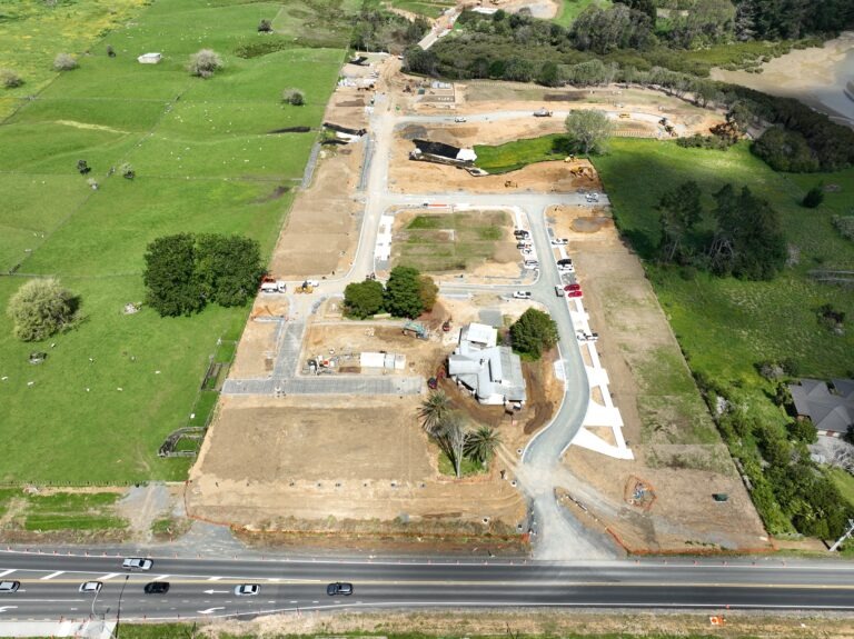
- Auckland
- Delivered in two phases, Hingaia phase one will see a residential development for 89 homes. As part of the second phase, there is creation of a large causeway to access the back of the land to gain access to waterfront land. This ease way travels past wetlands, so has been carefully created and engineered to meet requirements.
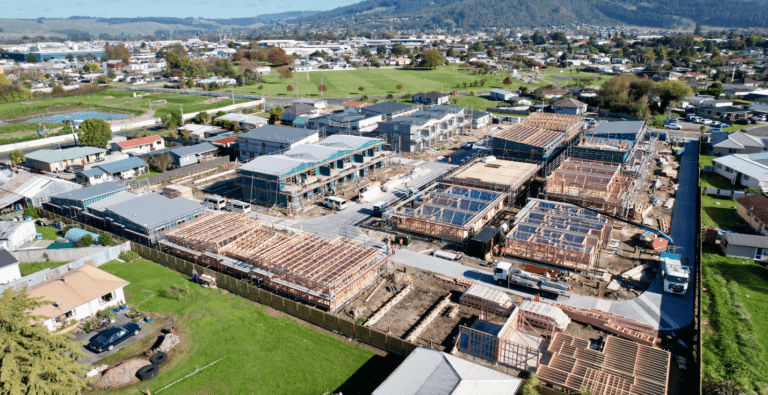
- Rotorua
- An intensive residential development delivering 52 homes in just 8 weeks, the Bennetts Road subdivision showcases rapid, high-quality housing delivery in Rotorua. McKenzie & Co supported fast-tracked civil and infrastructure design, enabling efficient construction and timely completion to meet urgent housing demand.
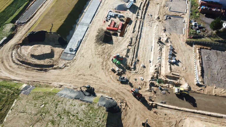
- Rotorua
- Subdivision of approximately 15.9-hectare site and construct approximately 196 residential units and supporting infrastructure including roads and reserves intended to vest with Rotorua Lakes Council, accessways, car parking areas and three-waters services. The project will include construction of a new intersection with State Highway 36, landscaping and planting of open spaces and the creation of a series of artificial wetlands for flood mitigation on a large balance lot.
Frequently asked questions
When do I need a surveyor?
Earlier than most people expect. If you’re buying land, subdividing, building near a boundary or applying
for resource consent, a survey at the front end costs far less than rework at the back end. A short
conversation will tell you whether you need one yet.
How long does a land transfer survey take?
Field work is usually a day or two. The longer part is the LINZ and council process, which typically puts the total at several months from first site visit to new title. We’ll give you a realistic timeline for your specific site before we start – not a best case.
What does a boundary peg actually prove?
A peg placed by a licensed cadastral surveyor marks the legal boundary as recorded in the title and survey records. It’s the only mark that carries legal weight. A fence, a hedge and a previous owner’s peg prove nothing — and in our experience the three rarely agree.
What affects the cost of a survey?
Site size, terrain, vegetation, the quality of the existing survey records, and how much of the boundary needs re-establishing. A flat suburban section with clean records is straightforward. A steep rural block with a survey from the 1920s is not. We quote on the site, not off a price list.
What do I receive at the end?
It depends on the job, but usually a survey plan, marked pegs on the ground, and digital data in the format your architect or engineer already uses. For subdivisions we carry it right through to the deposited plan and new titles.